It’s been quite a sometime since scientists were working towards obtaining insights and control over the occurrences and patterns of global wildfire. As per a research reported by Clark University geographers, carbon emissions from fires have escalated tremendously, between 1996 and 2008 is 2.4 times as much as what burned between 1984 and 1995. So in order to resolve the problem, scientists thought of having a dedicated geostationary satellite. Such technology would also help in averting catastrophes like Arizona’s Yarnell Fire, which killed nearly 19 Firefighters in US this summer.
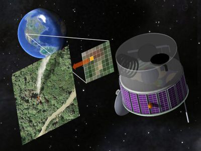
The FUEGO (Fire Urgency Estimator in Geosynchronous Orbit) satellite is a tool that researchers have offered to the firefighters. The satellite would loom over the Western states almost constantly taking pictures of the ground every few seconds in search of hot spots that could be newly ignited wildfires. As per the reports generated by FUEGO, timely action would be taken in terms of preventing the escalation of fires.
In the words of Scott Stephens, a UC Berkeley associate professor of environmental science and fire expert,
If we had information on the location of fires when they were smaller, then we could take appropriate actions quicker and more easily, including preparing for evacuation. Wildfires would be smaller in scale if you could detect them before they got too big, like less than an acre.
Feasibility of the satellite is made based on state-of-the-art sensors and faster analysis software, which would also minimize the risk of false alarms. FUEGO would overcome the challenge of identifying hotspots from sunlight shining on a mirror or windshield.
How it works
“In concept, this is a simple system: a telephoto camera, an infrared filter and a recording device. We are just looking for something bright compared to the surroundings or changing over time,” Kelly said. “Then, we do these rapid calculations to determine if one image is different from the next.”
Pennypacker and graduate student Marek K. Jakubowski developed a computer analysis technique, or algorithm, to detect these differences in space and time and to distinguish them from bright lights that might look like fires. This involves several billion calculations per second on images taken every few seconds, covering the entire West every few minutes. The new paper reports on tests of this algorithm using existing imagery from real fires, but the team hopes to get funding to test the system on a fire that is starting, such as a prescribed burn.
“The point is, satellites like Landsat and GOES provide great information after a fire starts; they can focus and monitor a fire by looking at smoke plumes, fire spread, hot spots at the edges, etc.,” Kelly said. “FUEGO is designed for early detection of smaller fires. Right now, we lose a lot of time because fires are already big by the time we see them.”
The experts are expecting frequent and extensive wildfires with the growing affect of global warming hence they are hopeful that FUEGO would assist in solving the problem at least in one season. Similar tool would also help other regions of the world such as Australia, where a line of fires is currently raging across 1600 kilometers west of Sydney.
Via: IEEE Spectrum and Eurekalert